
Iceland's Ring Road - Seyðisfjörður to Akureyri (Day 6)
UPDATED: 1/16/2023
Note: Some links throughout our site are affiliate links, which means we may receive a small commission at no cost to you.
We left the eastern fjords where we’d stayed in the harbor town of Seyðisfjörður and headed northwest to the second largest town in Iceland - Akureyri.
The entire drive for the day was scheduled to take about 5 1/2 hours (not factoring in stops along the way). All of the stops we hoped to see would be in the second half of the drive, after a solid 2 hours and 45 minutes of driving. The drive was similar to what we had gotten used to in Iceland - a variety of scenery that constantly evolved. We drove through windy passes down from the mountains that we were leaving behind with sweeping rivers and verdant fields on both sides of the road in valleys that meandered up to more mountains. We drove through a long section of a lava field that had large rock cairns stacked on the side of the road to mark a trail.
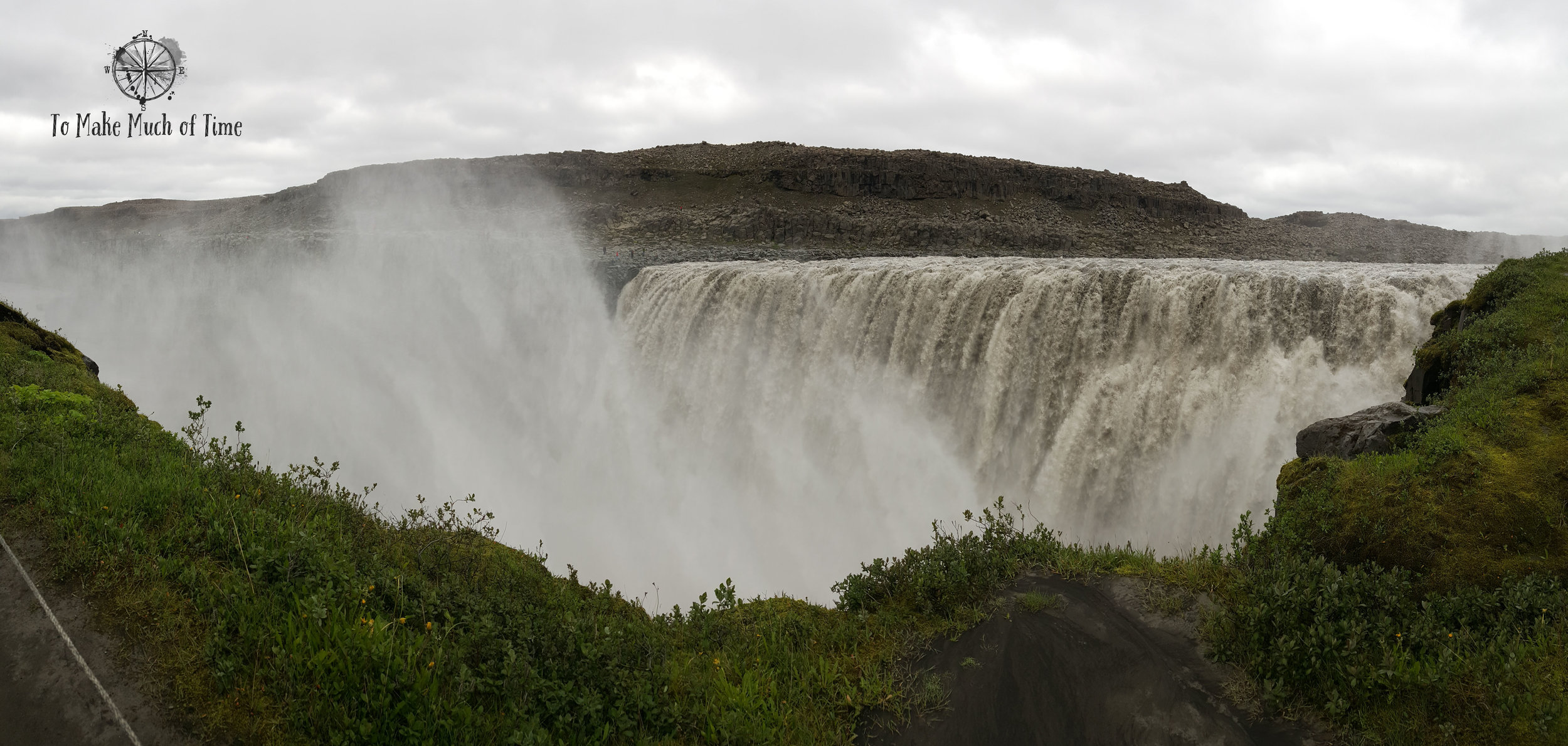
We came to the spot where Rt 864 veered off to the right and took the 20 mile detour to visit two enormous and beautiful waterfalls that are nearby each other: Dettifoss and Selfoss . We were able to park and take a short hiking path to visit both. First up was Dettifoss, which has the greatest volume of any waterfall in Europe with 500 cubic meters of water plunging down every second.
As we walked toward Selfoss, about a 30 minute walk on a rocky ground, we were following the source of the water feeding Dettifoss. Coming to Selfoss, it was no wonder what was creating all that voluminous water! Selfoss is not a tall waterfall but an endless one, sweeping around a u-shaped drop-off. I think until this trip I had not really appreciated the varied nature of waterfalls. When I hear the word, I tend to think of a very standard, basic one, but that does not do justice to nature’s creativity in moving massive amounts of water over precipices. While these falls are a little bit of a detour from the Ring Road, they are absolutely worth it.
Obligatory selfie at Dettifoss, Iceland.
The number of individual waterfalls that make up Selfoss is just incredible.
A little more than an hour later, we stopped for a visit at the Krafla Power Station, owned by the national power company. Next to the main building is a small visitor’s center that had a short video as well as various models, photos, and other information. The proprietors there were incredibly friendly and excited to share their passion for geothermal energy with visitors.
Feeling more educated on the science of the energy source, we explored the power station’s property, which has various hiking routes available to the public. And yes, it did feel odd that a power company would have a visitor’s center where friendly people offered coffee, that its property would be open to the public for hikes, and that the setting of the hikes would be beautiful enough that you would want to take pictures of it. And so then it is also no surprise that people from countries around the world have been visiting Iceland to learn more about their power sources that leverage nature.
Just past the power station (turning left out of the visitor’s center), we drove a short ways to Viti Crater , which is the remains of a volcanic eruption in 1724. Other volcanoes in the area have been very recently active.
There is a hiking path that goes up and around the rim of the crater, which is filled with deep teal water. The width of the crater is about 1,000 feet, and as you hike around it, you realize how deceptive the height and size is. People across the way and headed up the trail look quite small. At one point in the trail, it dips to a lower altitude and crosses a narrow area among steaming vents and would be dangerous to step outside of the casually roped-off trail.
We saw a few other craters with oddly colored land from the various metals in the earth and steam spewing from deep in the ground. The path was incredibly muddy, and by the time we finished, we were walking on multiple inches of caked-on mud that we tried to scrape off, only somewhat successfully!
The smell of sulfur, the bleak landscape, and vents of steam make this feel like a post-apocalyptic world.
Steam and sulfur escape through numerous vents. Watch your step or your shoes will melt!

The turquoise waters of Viti Crater at Krafla Power Station
Leaving Krafla Power Station we were greeted with absolutely breath-taking scenery.
If we thought the colors and the steam of this active volcanic area were amazing, we were only getting started. Right on the other side of the Ring Road and visible from the route is an area known as both Hverir and Námafjall Geothermal Area.
This large area is filled with steaming vents, boiling mud pools, bubbling water of all colors and, of course, the smell of sulfur. The area is incredibly hot and dangerous if you aren’t careful. Portions are lined with ropes to indicate safe paths, and there are bridges over other parts. This is clearly a very popular area and had a lot of tourists, making it difficult to get good photos. Signs warned that people have been seriously injured for leaving the path but of course we saw people leaving the path anyway due to the common ailment of tourist invincibility.
The largest Mud Pot at Námafjall Geothermal Area
Be careful, the hike is slippery but beautiful.
We eventually made it to the top!
Back down the other side.
We noticed that there was a hiking path up the mountain overlooking the area, up Namafjall Mountain. The trail is a loop trail that basically goes up one side, meanders along the top, and descends on the other side and takes an hour or so to complete and is about 2 miles in length. We took the left route up and the right down.
The route up the left of the mountain was quite treacherous - the ground is entirely slippery gravel rocks that make it impossible to get truly solid footing. One area was so steep, that I literally had to grab on to the one piece of stable ground nearby - I think it was a root of some sort sticking out under a large boulder - to haul myself up. While that was the worst of it, the path up from there was also very steep with unclear markings as to the safest route to go, and to maintain balance, I had to really lean forward.
That was the hike on the trip most outside of my comfort zone, and what was most disconcerting is that it was essentially a barren heap of gravel so if you lost your balance, there would be nothing to slow you down or break your fall down the hillside. That said, it was absolutely worth it once we got to the top and were able to enjoy more bubbling and boiling water, sulfur pools, and absolutely amazing views.
There was an outcrop that provided a 360 degree view of the Lake Mývatn region. The path down on the other side was much better, and I’ve since read some other reviews online that recommend you go both up and down the right side. Yes, that would make for a longer hike, but that is what I would do if I went again.
A stunning panorama! The various flat topped mountains are actually volcanoes!
Back on Ring Road with one more stop on our route for the day - Goðafoss waterfall - about 45 minutes down the road. There is a short walk from the parking lot, and you aren’t able to see the waterfall until a little ways down the path. This is a very popular site and had a decent number of visitors. There is a small stairway cut into the rocks to take you down to the water’s edge and to the final viewing spot. The waterfall is somewhat reminiscent of Selfoss in that the drop of the falls is not far, but it is nearly 100 feet wide against dark rocks that make it look all the more dramatic.
The name Goðafoss means Waterfall of the Gods. The history of this name dates to around 1000 when there was a debate about whether Iceland should follow Christianity or its prior Norse religion. There was pressure from Norway to convert to Christianity or risk invasion, and this decision was weighed and discussed at Þingvellir (you can read more about that site in our prior blog here. The head of the meeting was a priest by the name of Þorgeir Ljósvetningagoði, and he was given the responsibility of making a final decision. He determined that while people could continue practices their old beliefs in private, Christianity would be the new religion. When he returned home, he threw idols symbolizing his old gods into the waterfall, which then became known as Goðafoss.
One of Iceland’s many gorgeous waterfalls Goðafoss is absolutely worth the visit.
After a long day in the car with amazing adventures and sights, we steered towards what would be our stop for 3 nights - the coastal town of Akureyri, population 18,000, which sits at the base of one of the country’s longest fjords, Eyjafjörður.
Keep reading our road trip adventure here!
Click the image below to save this post to Pinterest!
Check out more of our posts on Iceland:


Akureyri and Grímsey Island (Days 7-8)
Have you been waiting for puffins? Keep reading to get your puffin fix…