
Pocahontas County, West Virginia Trip Overview - 4 Days in the Mountains
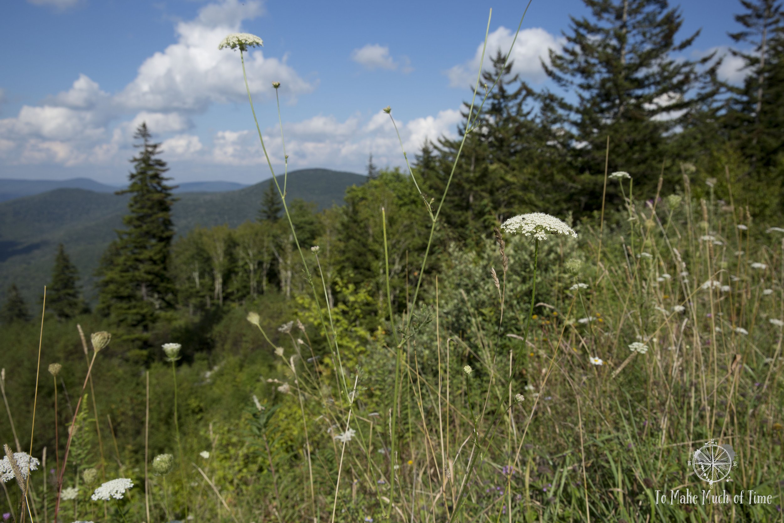
View from Highland Scenic Highway
Related blogs: Want to read more about our travels in West Virginia?
Note: Some links throughout our site are affiliate links, which means we may receive a small commission at no cost to you.
West Virginia is known as the Mountain State for a reason. While many states dip into the Appalachian region, West Virginia is the only state entirely within the Appalachian region. And because the Appalachian system of mountains is so vast - spanning from Georgia to Maine - it has sub-sections of mountains. West Virginia is home to the Valley and Ridge and Appalachian Plateau areas, the former of which is nestled against the Blue Ridge Mountains of our local area in Virginia.
So, what do all of these mountains get you? Amazing hikes, bikes, views, and scenic drives! During our four days in Pocahontas County, in the eastern portion of the state, we were able to take in amazing sights and barely scratched the surface of just that small area alone. We loved it so much that we have already planned another West Virginia trip next spring to a different area.

Cowpasture Trail (7.5 miles) in Cranberry Glades

One of the many enormous rocks at Beartown State Park

We got many great butterfly shots throughout the trip including this fella on a thistle.

Watoga State Park is designated as an International Dark Sky Park so we stargazed several nights of our trip.

Hiking around the shores of Lake Watoga

The tail end of sunset at Watoga State Park
Planning our Pocahontas County, WV Trip
how we determined our destination: Pocahontas county
Ending up in Pocahontas was entirely due to serendipitous factors and turned out to be a lucky find! After over 2.5 years of no travel due to Covid precautions, we decided we were ready to venture out into the world in as safe a way as possible - to visit somewhere within a short drive where our activities would be pretty isolated from other people.
Since we live in the western portion of Virginia, West Virginia is only a short drive away. We realized that while we have driven through West Virginia on a number of occasions, we have never actually visited the state intentionally. Because we wanted to take our three large dogs with us, basically any vacation rental options were off the table, and camping was a non-starter since we wanted to enjoy the outdoors without the pups, too. We found our way to the West Virginia State Parks site, searched for dog-friendly cabins, and found Watoga State Park, a great jumping off spot to explore Pocahontas County.

Can you spot all 3? The girls were already tired just an hour into the trip - so much excitement for them!

A unique sighting of a double-decker dog. Gretchen decided Sophie’s head looked comfortable, and Sophie didn’t protest.
where we stayed in pocahontas county, wv
Watoga State Park is the largest of the state’s 35 parks, racking up over 10,000 acres to its name. The park sits at about 3,000 feet in elevation, making it a cooler spot in the summer than lower elevations.
Within Watoga State Park are 2 distinct camp sites and 34 cabins. The cabins - as is common throughout much of the state’s park system - are primarily designated as either ‘legacy’ cabins or ‘classic’ cabins. The legacy cabins, which reflects the type of cabin in which we stayed for our trip, were built as part of the Civilian Conservation Corps (CCC) in the 1930s, part of President Roosevelt’s New Deal during the Great Depression as a way to improve the country while also putting people to work. The cabins at Watoga wear their years well and have been well-maintained and up-graded.
The cabins are built in combination of wood and stone-work. They vary in accommodation size from two to six-person cabins and have modern amenities appropriate to their rustic-nature: meaning, they have a kitchen and bathroom but no phones, TV, or internet. The cabins also have linen service so we did not need to bring any sheets or towels ourselves.
The cabin we stayed in - #4 - was cozy. While it sleeps four people, the standard lay-out of the cabins doesn’t lend itself to separate bedrooms. The main (double-sized) bed was in the central room of the house with the kitchen, family room, and eating area. There were two twin bed sized spaces that were alcoves off of the main space, each just large enough for a twin bed and with a curtain to provide some privacy.

This was the main room of our cabin and shows the kitchen, dining table, and double bed. Behind the curtains lurks one of the twin sized beds. Down the visible hall is the bathroom and the second twin bed alcove. Behind the photographer’s back is the fireplace and sitting area. (The kitchen has a fridge, and it’s just to the left of the oven.

The rustic nature of the cabin meant that it had some - uh - rustic features. For example, it was fairly damp and chilly and smelled like the wood from the fireplace. This fit with the ambiance and was just fine for campers like us. I did end up getting a sweatshirt from the gift shop because even though it was August, the damp cabin made it chilly! While we had some bug visitors and one notable-in-size spider who joined us through openings at a few spots in the walls, they were quite minimal, all things considered. We did not see any mice or evidence of them (besides a trap set up near the crawl space), though cabins in parks are often a hotbed of small rodent activity.

Droop Mountain Battlefield State Park’s Overlook Trail. Our first travel selfie in about 3 years. Still got it!

A view along the Greenbrier River Trail, which we biked.

Tea Creek Meadow Trail off of the Highland Scenic Highway

Lake Watoga
what were the highlights of our trip to pocahontas county, wv
Honestly, it is hard to narrow down the best parts of this trip. While pretty much every aspect of our time had one thing in common - being outdoors - the various sights were all unique. Our four posts that will follow this one will go much more in depth into each part of our trip, so further reading there is recommended! But. If we have to identify a few highlights to whet your appetite they would be:
- Beartown State Park - We had no plans to go here until a park ranger at Droop Mountain Battlefield State Park recommended it and handed us a map. It was only a short drive away and sounded interesting but wow was it amazing! The main highlight is a half mile boardwalk path that weaves in and out of an alien terrain of huge boulders and rocks, all under the canopy of trees. It was peaceful - one of those spots that you feel compelled to whisper. Weirdly, it reminded us of a spot we visited in Iceland.
- Greenbrier River Trail - Until we planned the trip, we were completely unaware of this nearly 80-mile rails-to-trails route that runs right near Watoga. It runs along the river and passes through small towns. We brought our bikes and enjoyed a 14-mile ride, easy to access from Watoga. There are sporadic campsites along it to encourage distance travelers, which piqued our interest as something we may want to do in the future.
- Sunset viewing and stargazing at Watoga State Park - Watoga is certified as an International Dark Sky Park, meaning that it has minimal light pollution. Add to that the hilly terrain, and there are some great spots to take in the sunset and stick around to watch the stars come out.
- Cranberry Bogs Botanical Area's Boardwalk Trail in Cranberry Glades - This boardwalk trail is short, only 0.6 miles, but it is a really unique spot. The bogs that reside here are typically found very far north (think: Canada) but the microclimate has been conducive. Some of our favorite spottings were carnivorous plants.
- Cowpasture Trail in Cranberry Glades - The trailhead to this 7.5 mile loop trail is near the boardwalk and winds through a boggy area of its own before meandering in and out of various environments - from forests to meadows and everything in between! An unexpected historic find - early into the hike there were a number of placards with information and images of a jail that used to be housed in the meadow. The inmates weren't penned in because the site was so rural and the boggy area was so rough, they had no where to esacape to.
- Highland Scenic Highway - We followed a large portion of this scenic highway and found ourselves enjoying the varous overlooks, views, and even though we planned to only drive, we took a few hikes along the way including Tea Creek Meadow Trail because we couldn't help but explore!

Beartown State Park
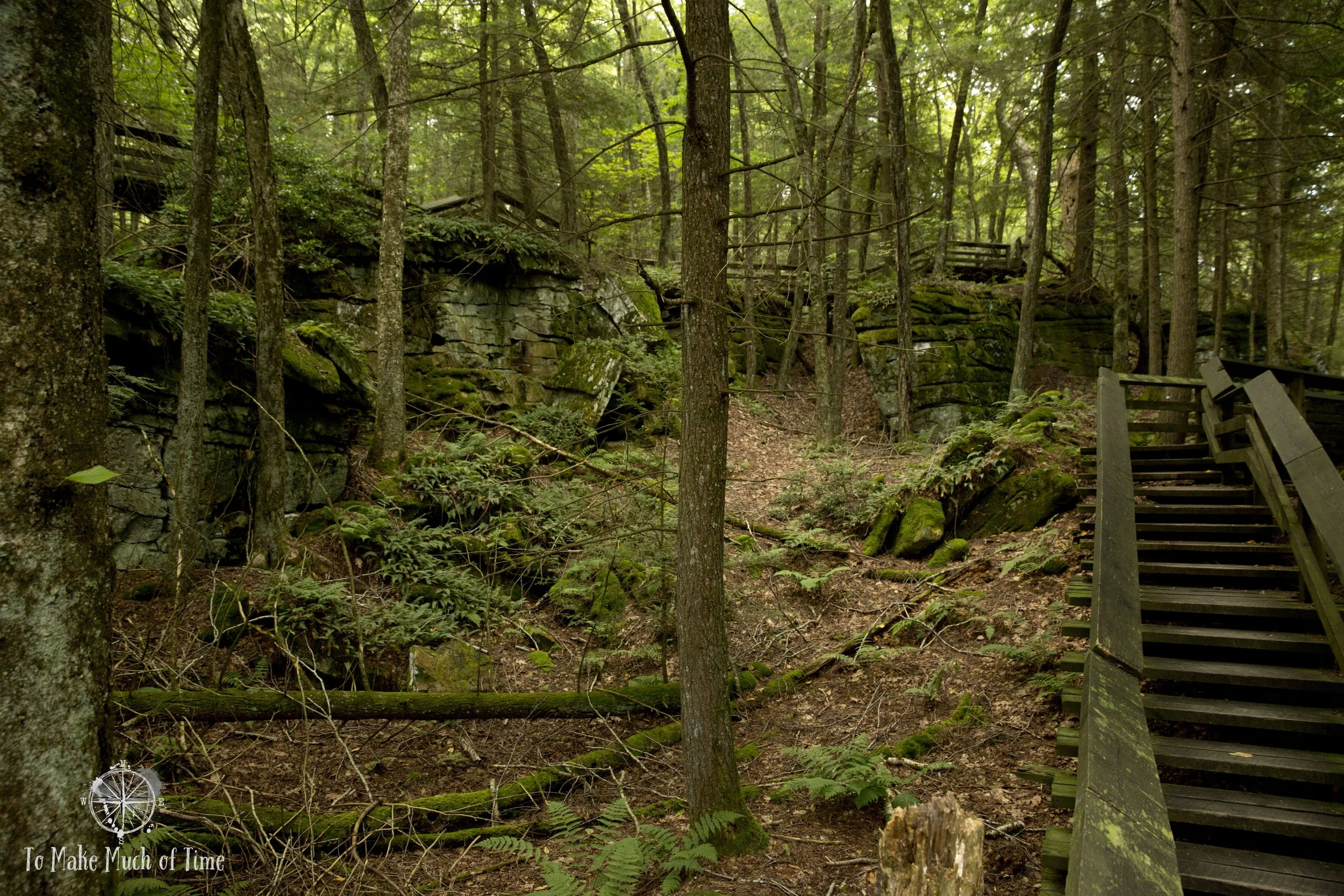
Beartown State Park
Would we return to Pocahontas County, WV?
Absolutely! The area has endless outdoor spots to explore and at least during our trip in late August, there were not any crowds. We have booked our next West Virginia trip to some surrounding counties to continue exploring the region.

Hiking Big Spring Trail at Droop Mountain Battlefield State Park

Biking the Greenbrier River Trail

Biking the Greenbrier River Trail
Trip Do-Over: What would we do differently?
We ended up exploring fewer hikes in Watoga State Park proper than I would have liked; however, that was more a function of the length of our trip. We had planned on a slightly longer trip but between rain the last day and a conflict that prevented us from leaving when we’d planned, we cut our planned 5-night stay down to three. If we had spent the originally planned amount of time, I think that would have been good for additional exploration.
While we sort of assumed we wouldn’t have strong cell or internet service, we were still surprised to find that pan out. In Watoga State Park, we had to drive to the park headquarters to tap into their wifi on a regular basis to check the weather and other important safety measures when traveling. Our cabin did not have service. When driving on a lot of the hilly roads in the area, we sometimes had internet connectivity on our phones, sometimes not, and we often found ourselves without cell service. Keeping that in mind, I’d recommend printing out directions in advance (or saving routes into your phone when possible) and doing some pre-trip homework into local spots you may need to know - like where the local grocery store is, for example, just to make life a tad easier.

Cowpasture Trail in Cranberry Glades

Cowpasture Trail in Cranberry Glades

Tea Creek Meadow Trail off of the Highland Scenic Highway

Lake Watoga

Cranberry Bogs Boardwalk Trail in Cranberry Glades

Lookout Tower at Droop Mountain Battlefield State Park
Our Pocahontas County Route
Below is our approximate route during our time in Pocahontas County. This was not a route we took all in one day but highlights the ground we covered and the rough distance. Pocahontas County is quite large and driving from the northern to southern borders on major roads takes over an hour. We more-or-less stuck to the southern part of the county. At the bottom of this post is a map of the area we covered on the trip. We tackled Droop Mountain Battlefield State Park and Beartown State Park on the same day since they’re so close. Our trek to Cranberry Glades Botanical Area for a couple of hikes, including one that was 7.5 miles was its own day, and then the loop at the top was our drive on the Highland Scenic Highway with some hikes off the road.
Click the image below to save this post to Pinterest!
