
Canaan Valley 2-Day Itinerary

Seneca Rocks
Note: Some links throughout our site are affiliate links, which means we may receive a small commission at no cost to you.
This is the third post in a series for this trip. You can view links to the other posts at the bottom of this one.
Two day itinerary for Canaan Valley, West Virginia
Canaan Valley (pronounced kuh-NANE) is a beautiful valley in the northeastern portion of the state. It is known for being the location of Blackwater River and its eponymous state park, an area with a number of ski/four-season resorts (while it’s known for the Canaan Valley Resort, there are others), home to Dolly Sods Wilderness, and neighbors the towering peaks of Seneca Rocks. If you like the outdoors, this is a spot to add to your list!
MAKE THE MOST OF TWO DAYS IN canaan valley
Tip: We found staying in the area around Davis to be a good spot to easily access all the area has to offer. We rented a really unique home from VRBO (read more about our stay here or check it out on VRBO).
You could easily spend a week exploring and hiking through just Dolly Sods, which has plentiful backcountry hiking opportunities. If you have two days like we did, you might enjoy getting a peek at a variety of offerings in the area. Technically we had 2.5 days so…

View from Seneca Rocks
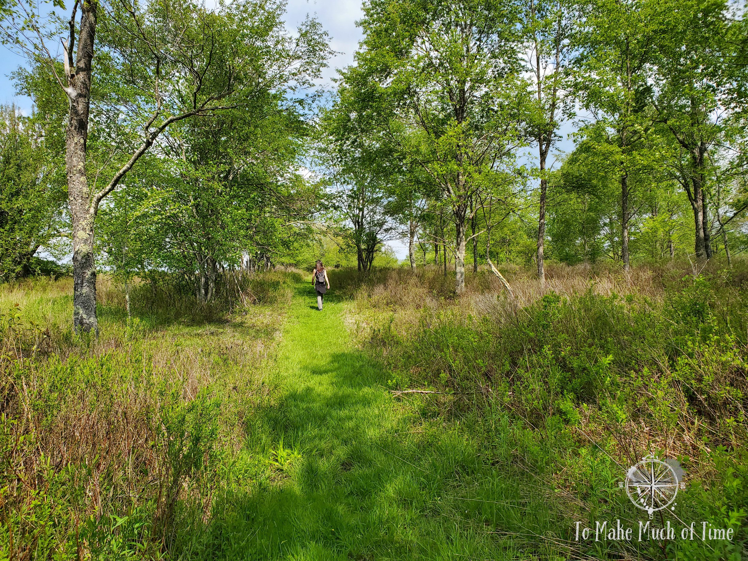
Hiking through a meadow at Canaan Wildlife Refuge
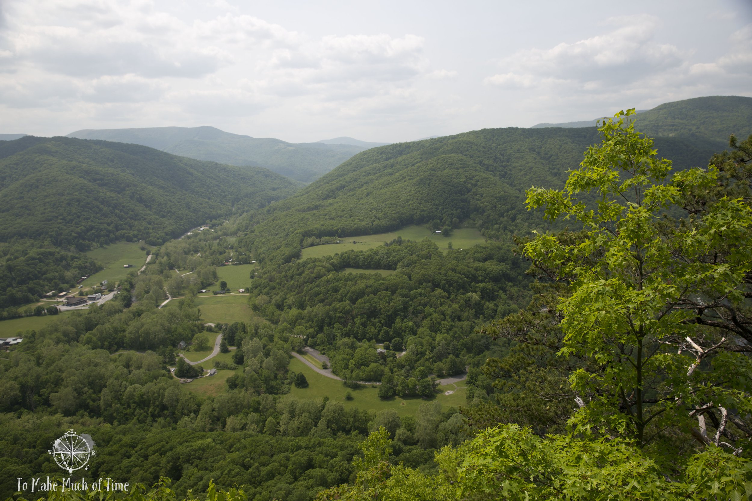
Day 1 (a half day, as we traveled in from New River Gorge National Park - read about that here): The drive from Glen Jean to our new destination of Davis, WV, is about 3 hours. Seneca Rocks only adds a little extra out-and-back to the trek for a total driving time of 3 hours 40 minutes so we decided to get some hiking in after a lot of driving. The drive from the New River Gorge National Park area to Canaan Valley was gorgeous as the road swept up, over, and down the mountainous area. Seneca Rocks, fully visible from the road, is worth seeing for those uninterested in hiking up. Our fitness tracker clocked in the hike as 2.9 miles total in just under 90 minutes. The view from the top is a sweeping vista of the surrounding area. We made it to our rental house in Davis in time to get settled in, enjoy a beautiful sunset off the back patio, and grab a bite to eat from a local Italian place, Mama Mia’s Pizza & Subs.
Day 2: We headed to Dolly Sods Wilderness to hike from Fisher Spring Trailhead, which was easy to find after a rural drive on gravel roads. While we originally planned to take a larger loop trail off of this one, the trail was particularly slow going with a lot of muddy patches and creeks to wade through. Since we hadn’t brought lunch, we shifted our plans and instead we did a total of 2.5 miles out-and-back in about 2 hours and then drove down the road to a picnic site and refueled. In the afternoon, we headed over to the Canaan Wildlife Refuge trailhead area and selected the southern hike and clocked in a solid 3.5 miles in 1 hour 40 minutes. This trail weaved in and out of wooded areas, fields, and had an unexpected section with antique farm equipment and information panels. For dinner, we ordered out from Milo’s Cafe and Restaurant at Bright Morning Inn in Davis proper. Our party tried a couple of burgers - green chile burger and sweet and spicy bacon burger - as well as the garlic buffalo shrimp wrap. All of our meals were tasty!
Day 3: On our final day, we decided to check out Blackwater Falls State Park, located just outside of the town of Davis. We spent roughly four hours in the park and while we didn’t see all the sites the park has to offer, we explored a variety of spots: Blackwater Falls, the tallest waterfall in WV coming in at sixty feet high; Pendleton Point Overlook; hiked the Pendleton Trace Trail to the Dobbin House Trail; and finally, stopped at Lindy Point Overlook before plopping ourselves down at a picnic table near the Lodge for a late lunch. We grabbed dinner at Hellbender Burritos, which had strong reviews and which we really enjoyed.
Planning Our Time In Canaan Valley
For years, we have talked about wanting to visit Seneca Rocks and Dolly Sods Wilderness. Dustin had been to both when he was in school and had fond memories. For whatever reason, we had never gotten around to planning a trip to check the area out, even though the drive from our house is reasonable for a long weekend.
So, when we built our itinerary for a week-long trip to West Virginia, we determined that was the time to visit these two spots! When we checked out what else was in the area, we added Blackwater Falls State Park to the list because my response to a waterfall is always yes!
Day 1 in Canaan Valley: Seneca Rocks
hiking seneca rocks
As you approach Seneca Rocks in the car, the white rocks, formed of Tuscarora Sandstone back when this area was at the bottom of the sea, are visible from a ways off. They are a stark and surprising jutting of stone in an area that is filled with green tree-filled mountains. By the time we parked in the very large and nearly empty parking lot an looked up, they looked intimidatingly high, creating about 900 feet above us. Near the parking lot is an outhouse and a luscious green lawn with the occasional picnic table. It’s easy to picture the parking lot filled and the lawn strewn with picnickers on another day but we were in the quiet of pre-season travel.

Bridge over North Fork River at the base of Seneca Rocks

North Fork River at the base of Seneca Rocks
At the base of Seneca Rocks is the North Fork River, offering some picturesque views of the flowing water and bridges to carry hikers over it. There are warning signs about the over-zealous hikers and climbers who have come before and fallen from the peak.
The hike up was - as you might imagine - entirely uphill. There were sections of stairs and switchbacks and so while it’s an elevation climb of 900 feet over 1.5 miles, it wasn’t as strenuous as it could have been. There were a few benches along the way for hikers to rest, and we passed hiker of all ages and in all levels of physical shape. The trail is very well maintained.

Seneca Rocks

Trail up to Seneca Rocks

View from Seneca Rocks
View from Seneca Rocks
There is a wooden platform at the top of the mountain, offering sweeping views of the surrounding valleys. It was a nice place to stop and take in the scenery before heading back down, which went quite quickly with an entirely downhill angle.
Including the time we spent relaxing at the peak, we were on the trail just under an hour and a half, covering the 3-mile distance.
Day 2 in Canaan Valley: Dolly Sods Wilderness and Canaan Wildlife Refuge
hiking dolly sods wilderness
With 47 miles of established hiking trails, over 17,000 acres, and over 2,000 feet in elevation changes from the Wilderness’ high to low points, Dolly Sods Wilderness is a fascinating, diverse area to explore, and one with an interesting history. Named for the German family Dahle (Americanized to Dolly), this pristine area served as a spot for the military to test artillery in the 1940s. In fact, at the start of our hike was a sign warning of the potential for unexploded ordnances. Uh… The government worked to clear out as many unexploded devices as they could in 1997 but like a needle in a haystack, there are sure to be others left behind. A quick search turned up an article from 2014 about a mortar that had been discovered.

Warning about explosives in Dolly Sods Wilderness. My favorite part: “if you did not drop it, do not pick it up.”

Fisher Spring Trail at Dolly Sods

Fisher Spring Trail at Dolly Sods

Fisher Spring Trail at Dolly Sods
Unexploded devices aside, Dolly Sods feels like an isolated wilderness. It is in the eastern part of West Virginia, an area not very populated, and it felt to me much more like hiking in the Western US in its isolation.
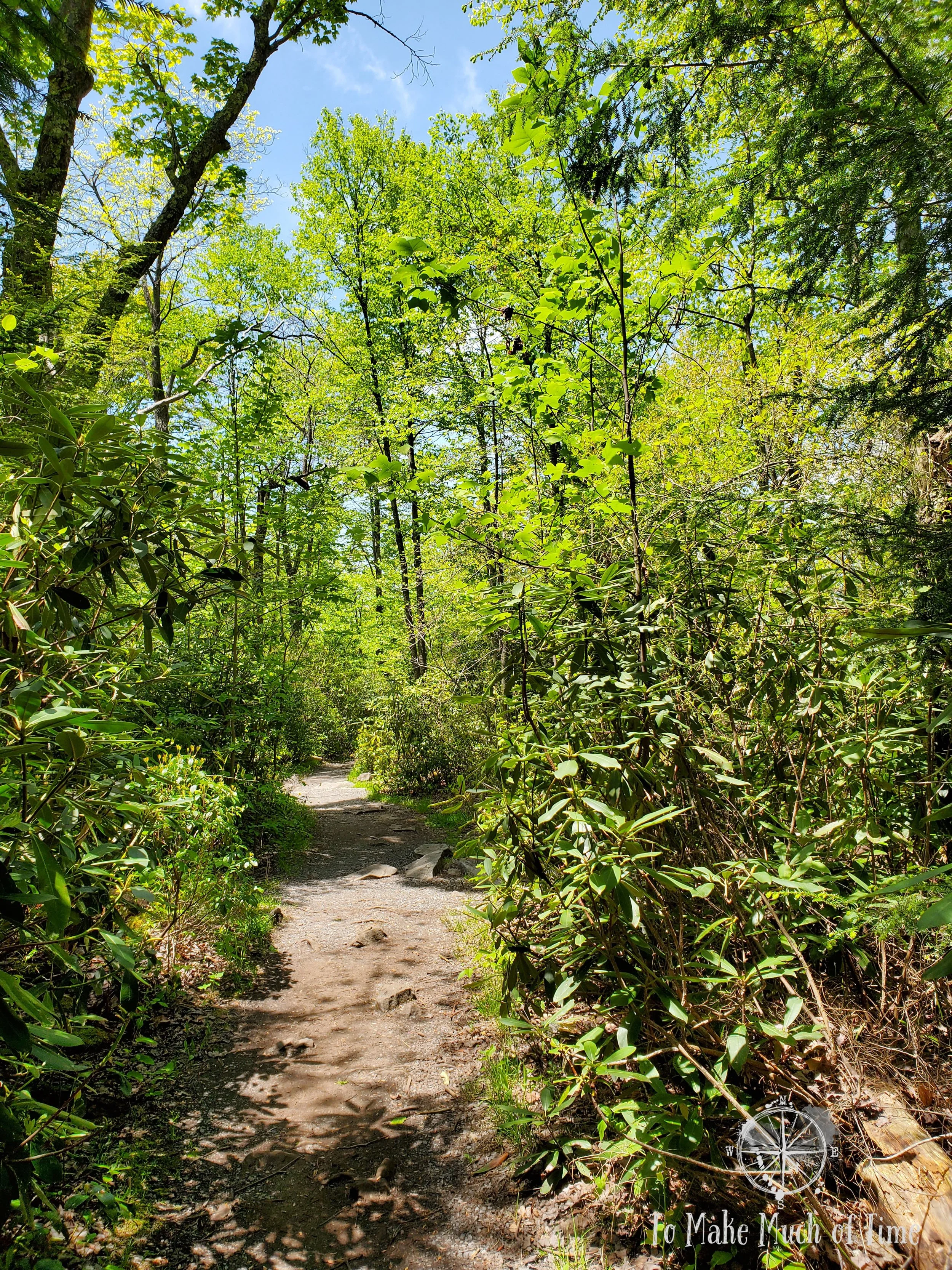
Dolly Sods has a number of day hikes accessible from what are best described as fire roads, and many of the hikes in the area stretch off from those access points and are great for multi-day backpacking treks. We decided to take the Fisher Spring Trailhead, which was easy to find after a rural drive on gravel roads. While we originally planned to take a larger loop trail off of this one, the trail was particularly slow going with a lot of muddy patches and creeks to wade through. Since we hadn’t brought lunch, we shifted our plans and instead we did a total of 2.5 miles out-and-back in about 2 hours and then drove down the road to a picnic site and refueled.
This is definitely a site I want to return to and explore through a longer hike.

The road in Dolly Sods Wilderness

Hiking Fisher Spring Trail at Dolly Sods

Fisher Spring Trail at Dolly Sods

Fisher Spring Trail at Dolly Sods

One of the many creeks we crossed on Fisher Spring Trail at Dolly Sods

A hint of the mud on the path at Fisher Spring Trail at Dolly Sods
visiting canaan wildlife refuge
The Canaan Valley is largely a wetland formed from portions of the Blackwater River and its tributaries. Over 5,500 acres of the valley are part of the refuge, a significant portion when the total valley is about 8,400 acres. Canaan Valley is in fact the largest wetland system in the state of West Virginia. Nestled within the refuge are a number of trails for hikers, bikers, horse riders, and cross-country skiers, though not all trails allow all of these modes.

Farm View Trail at Canaan Wildlife Refuge

Farm View Trail at Canaan Wildlife Refuge

Farm View Trail at Canaan Wildlife Refuge

Antique farm equipment on the Farm View Trail at Canaan Wildlife Refuge

Ferns on Farm View Trail at Canaan Wildlife Refuge

Antique farm equipment on the Farm View Trail at Canaan Wildlife Refuge

Farm View Trail at Canaan Wildlife Refuge

Farm View Trail at Canaan Wildlife Refuge
I found their trail maps to be a tad confusing both online and on-site. In any case, we selected the Farm View Trail from the more southern parking lot. The trail started near a gravel parking lot and crossed over a large, open meadow before weaving in and out of wooded areas and fields. Unexpectedly, one segment had numerous pieces of antique farm equipment and information panels describing their use and providing history of the area.
By the time we had looped back to the car, we clocked in 3.5 miles over an hour and 40 minutes of hiking time.
Day 3 in Canaan Valley: Blackwater Falls State Park
On our last full day of the trip before heading home, we set out for our destination: Blackwater Falls State Park, located just outside the town of Davis, West Virginia. Blackwater Falls State Park is home to its eponymous waterfall, which is the highest waterfall in the state, clocking in a height of about 60 feet. It is also home to several other sites including Elakala Falls and the Lindy Point and Pendleton Falls Overlooks. There are several hikes within the park, most of which are relatively short in nature.
The park is home to the Smokehouse Restaurant, located in the Lodge, which serves breakfast, lunch, and dinner daily, providing an alternative to picnicking. For us, we picnicked at a picnic table near the lodge.
The state park map, which is available online, is quite hard to read. This is coming from people who have visited other West Virginia state parks and read the similar style maps without any problem. The main challenge we had was the relative scale and the ability to tell where to access key spots identified on the map. The trail descriptions were also lacking a lot of key information. We did not find better signage in the park as we’d hoped and in fact did not come across any paper maps or large visuals. At one overlook, we saw a map that was different than what we’d seen online but its contents were equally opaque. In any case, the park is not huge and if you’re okay just driving around and trying to figure it out, you’ll do just fine. You can’t go wrong with pretty scenery!
Blackwater Falls and Blackwater Falls Boardwalk Trail
Located at the trading post and snack bar area, you can access the main sight of this park from the back left corner of the parking lot. There are not clear signs that label this trail, but it is clear that there is an entrance to something.

Blackwater Falls

Blackwater Falls

The stair-filled path down to Blackwater Falls
The Blackwater Falls Boardwalk Trail is only about a quarter of a mile in length (so half a mile down-and-back) and requires visitors to climb down and then up 200 stairs. There are a couple of different viewing spots for the falls, the last of which is relatively close and is the best viewing option. There is also a path called the Gentle Trail that will take visitors to view the falls without the large number of steps; however, we didn’t check that out so don’t know what the vista looks like.
Blackwater Falls is the tallest waterfall in the state of West Virginia at about 60 feet high and is quite pretty with the dark water falling over glistening rocks and other rocks rising up to the side of the waterfall.
pendleton point overlook
Located right off the road within the park and with a dedicated parking lot, Pendleton Point Overlook is an accessible spot to view the sweeping canyon below.

Pendleton Point at Blackwater Falls State Park in West Virginia

Pendleton Point at Blackwater Falls State Park in West Virginia
pendleton trace trail and dobbin house trail
After we drove just a slight distance down the road, we spent some time trying to find the trailhead to the Pendleton Trace Trail and finally located it! From there we hiked a distance out on this trail and met up with the Dobbin House Trail. Eventually we turned around and headed back for a total hike of 2 miles in a bit over an hour. A highlight on the trail, which was almost entirely wooded, was spotting an uncommon Pink Lady’s Slipper orchid.

Dobbin House Trail at Blackwater Falls State Park in West Virginia

Pink Lady’s Slipper Orchid on Dobbin House Trail at Blackwater Falls State Park
lindy point overlook
Further into the park, we checked out Lindy Point Overlook. There is a short trail through the woods to get to the overlook itself.

Lindy Point Overlook at Blackwater Falls State Park in WV
Path to Lindy Point Overlook at Blackwater Falls State Park in WV

Path to Lindy Point Overlook at Blackwater Falls State Park in WV

View from Lindy Point Overlook at Blackwater Falls State Park in WV

View from Lindy Point Overlook at Blackwater Falls State Park in WV

View from Lindy Point Overlook at Blackwater Falls State Park in WV
Click the image below to save this post to Pinterest!

Check out other posts in this trip series:


