
Great Lakes Road Trip: Mackinac Island and Toledo (Days 7-9)

View of Mackinac Island from the heights of Fort Mackinac.
UPDATED: 2/5/2023
Note: Some links throughout our site are affiliate links, which means we may receive a small commission at no cost to you.
Leaving Munising, Michigan and Lake Superior in our rear view mirror, we drove about two hours to St. Ignace, one of two ports that offers ferries to Mackinac Island. The other port, on the southern side, is Mackinaw City. We caught the ferry ride through Star Line Ferry.
One highlight of the short ferry ride was the amusing sight of a UPS truck sitting astride another ferry on the route over. Package deliveries are extra tricky on a car-less island!
I had read an article about Mackinac Island years and year before visiting. It was described as a car-less island full of Victorian era homes, and it intrigued me. So this was a must-add to our Great Lakes Road Trip route.

View of Mackinac Island from the path to Fort Mackinac. Lake Huron in the background, Marquette Park in the foreground. The long bike rack is an indication of the popularity of biking here!

Fort Mackinac - a slight indication of the very steep hike up to this fort. Originally built by the British in the late 18th century.

Fort Holmes, higher up the island from Fort Mackinac. Originally built by the British in the early 19th century.
Mackinac island: an overview
First a word on pronunciation. Mackinac (as in the island) is pronounced like “Mackinaw,” made extra confusing by the fact that on the mainland is Mackinaw City, spelled just like it sounds.
Mackinac Island can only be accessed by ferry (or plane - it does have a small landing strip), and once on the island, the transportation options are predominantly walking or biking. The island has strong bicycle traffic, and the main area near the port can get quite busy with bikes and walkers. There are also horse drawn carriages for the experience and used for the frequent weddings on the island.
The island itself is not large. The circumference is about 8 miles, and one of our most enjoyable activities was riding our rental bikes (there are many bike rental shops) on the route known as M-185, a walking and bike path that basically runs along the perimeter of the island, next to Lake Huron. The vast majority of the island (82% according to Mackinac’s tourism site) is part of the Mackinac Island State Park.
The majority of restaurants, shops (fudge is big here with salt water taffy and other confectionaries giving it a run for its money), hotels, and tourism life is embedded in a small town center section of the island near where the ferry docks. Up a very, very steep hill is Fort Mackinac, which dates to the late 18th century. Higher up the hill is Fort Holmes, which dates to the early 19th century.
The roads get much more limited outside of the main part of the island, and I’d say we biked pretty much everywhere on the island multiple times in our day there. Much of the island had very few people, and it was odd leaving behind the bustle of the town and finding ourselves pretty well isolate mere minutes later.

Wild flowers set against Lake Huron along M-185, the 8-mile road around the island circumference.

The path leading up to Fort Mackinac.

View of Lake Huron through Arch Rock
where we stayed on mackinac island
For our one night on the island, we stayed at Market Street Inn, located at the end of Market Street, right near Fort Street. It was a 0.2 mile walk from the ferry to the inn, making it easy to haul our suitcases and bags. The inn was also located at the end of the busy downtown area, making it feel less crowded than other areas. Just 0.2 miles uphill from it was the entrance to Fort Mackinac, and basically cattycorner from the inn was a big park, Marquette Park, that had live music the night we were there.
We had a pleasant stay, and the innkeeper was accommodating and friendly. When we arrived on the morning ferry, it was before check-in, and we were able to drop our bags off at the inn while we started wandering around the island. She was able to recommend a bike rental spot just down the street for us and, like other accommodations in the area, had an area for guests to store bikes.
Breakfast was included, and we had the enjoyable experience of eating it in the courtyard, enjoying the summer morning air.
Should we return to Mackinac, we would be happy to stay at Market Street Inn again.

Fort Holmes on Mackinac Island

The view of Lake Huron from within Fort Holmes. This was definitely a good spot to keep a look-out!

View of Lake Huron from Fort Holmes
where to eat on mackinac island
Unfortunately, we are not much help in this category! We grabbed a quick bite to eat somewhere for lunch, but for the life of me, I can’t remember where! For dinner, we found Yankee Rebel Tavern, which we enjoyed. I do remember that given the massive number of tourists, a lot of places were packed at meal time, so visitors may want to consider making reservations if possible.
what to do on mackinac island
While we certainly could have enjoyed a longer stay on the island, we were able to explore and do a lot in our 24 hours there given its diminutive size!
- Rent a bike and bike M-185 (8 miles) and the interior of the island - We rented our bikes from Mackinac Wheels. We biked the M-185 a couple of times and also biked up to Fort Holmes (after walking our bikes up the steep hill!)
- Explore Fort Mackinac for both the history and amazing views of the town below and Lake Huron beyond. Fort Mackinac dates to the late 18th century and was tossed back and forth between British and American troops in the era surrounding the Revolutionary War. There are multiple exhibits and fort buildings to explore.
- Visit Fort Holmes, whose origin lies with the War of 1812, when it was built as Fort George and manned by the British. When the Americans took over, they (understandably) renamed the site. Fort Holmes is in a desolate spot even further uphill from Fort Mackinac, and could easily be missed. We checked it out near closing time and enjoyed the views and quiet.
- Relax and enjoy the summer music series (Music in the Park) Thursday evenings at Marquette Park, along the water. We happened upon this after dinner during our stay. Others who had planned accordingly brought picnics and blankets. The concerts are free.
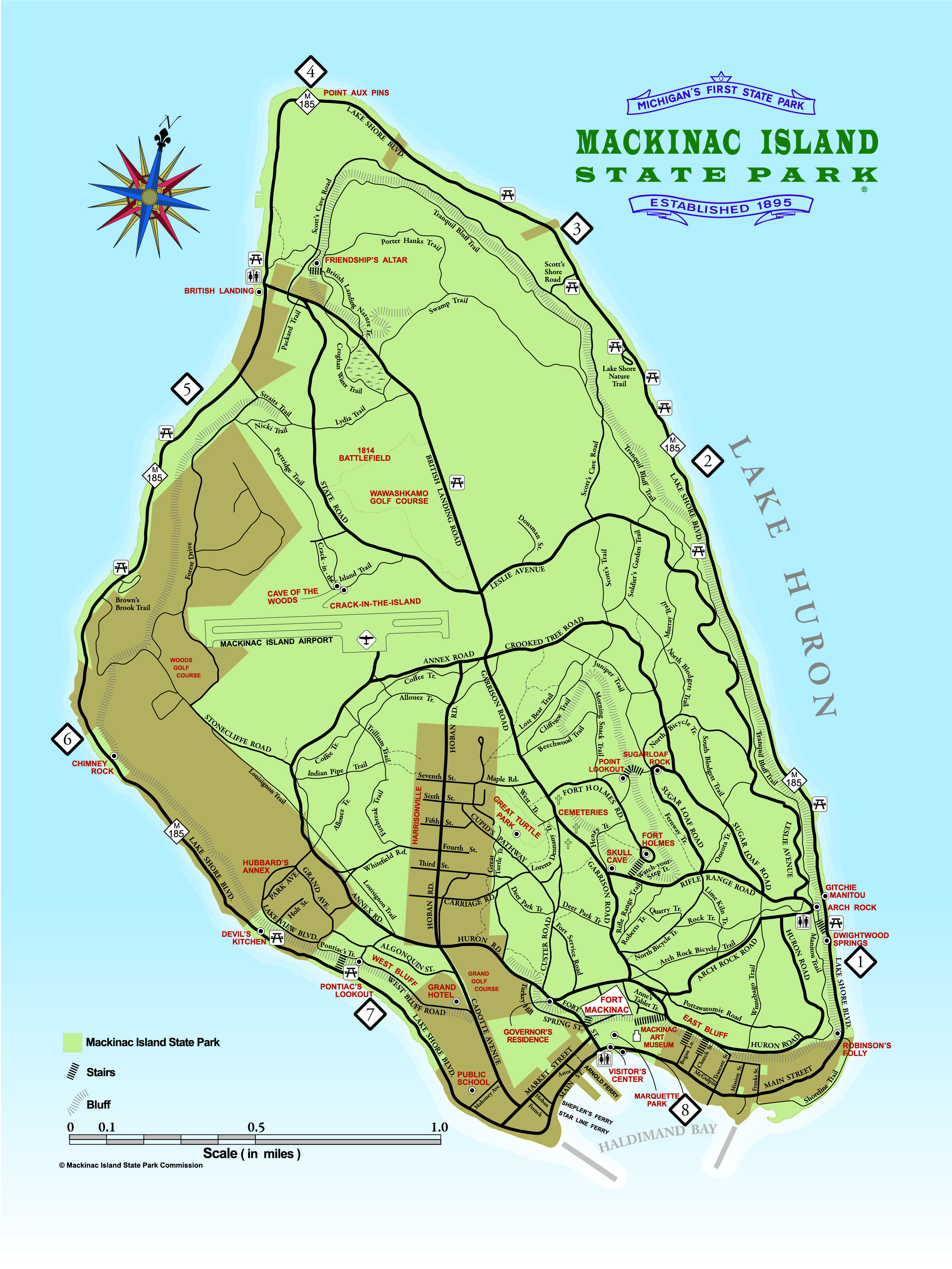
- Natural sites and historic sites along M-185 - there are many rock formations or other spots listed on the island map that are nice stops along a bike ride. A couple such spots are the Arch Rock and Devil's Kitchen. These landmarks and others are in red on the island map here.

The shoreline of Lake Huron, taken from along M-185.

The shoreline of Lake Huron, taken from along M-185. The colors of the water were brighter than we expected throughout much of our Great Lakes Road Trip!

The bridge in the distance connects St. Ignace to Mackinaw City.

Yellow wildflowers dotted the road when we biked into the center of the island.

A cannon at Fort Mackinac
After leaving Mackinac Island, our road trip was in the winding down stage. In order to cut up the long drive back to Virginia, we booked a night in Toledo, Ohio, giving us about 5+ hours of travel time from Mackinac Island to Toledo, Ohio, and then just under 8 hours remaining to make it home the following day.
Toledo sits on Lake Erie, adding a quick sight of that Great Lake to our Great Lakes Road Trip. We had booked the Marriott Courtyard Toledo - Maumee/Arrowhead and had no specific plans for Toledo other than using it as a stop-over.
But of course, there's nothing like finding yourself sitting in a hotel room and deciding you'd rather be out exploring. We checked the area map, discovered that the Toledo Botanical Garden was a short drive away, and headed over to explore.

Lavender and sculpture at Toledo Botanical Garden

This quaint area of Toledo Botanical Garden had a romantic stone structure, enveloped by vines.
toledo botanical garden
We love exploring botanical gardens whenever we come across them in our travels. We’ve been to such varied gardens as those in Phoenix, Arizona; Vancouver, Canada; Edinburgh, Scotland; and Akureyri, Iceland, some of the northernmost botanical gardens in the world. The parts of Toledo we saw while driving through the area were not pretty. It looked pretty economically depressed and run down. This was 2016 so the area likely has changed since then. All that to say, we did not have high expectations of what we would find at the Toledo Botanical Garden and found ourselves very pleasantly surprised.
Toledo Botanical Garden is comprised of 60 acres of gardens. You can view the map here. Sprinkled throughout portions of the garden were sculptures and other miniature worlds of walled gardens and vast open fields. I think that’s one of my favorite parts of exploring botanical gardens is that they are filled with magical little worlds, new surprises around every corner. We spent probably about 90 minutes wandering around and exploring. There were some other visitors but not a plethora.

A secret garden courtyard at the botanical garden.

Beautiful plumage of hostas

Route of this leg of our Great Lakes Road Trip below. For the overview of our entire road trip route, check out our overview post here.
Click the image below to save this post to Pinterest!

Check out our posts about the Great Lakes:


Looking for a desert road trip?
We’ve got you covered! Read about our week-long road trip through New Mexico.