
Pocahontas County, WV: Droop Mountain Battlefield State Park, Beartown State Park & Highland Scenic Drive (Day 2)

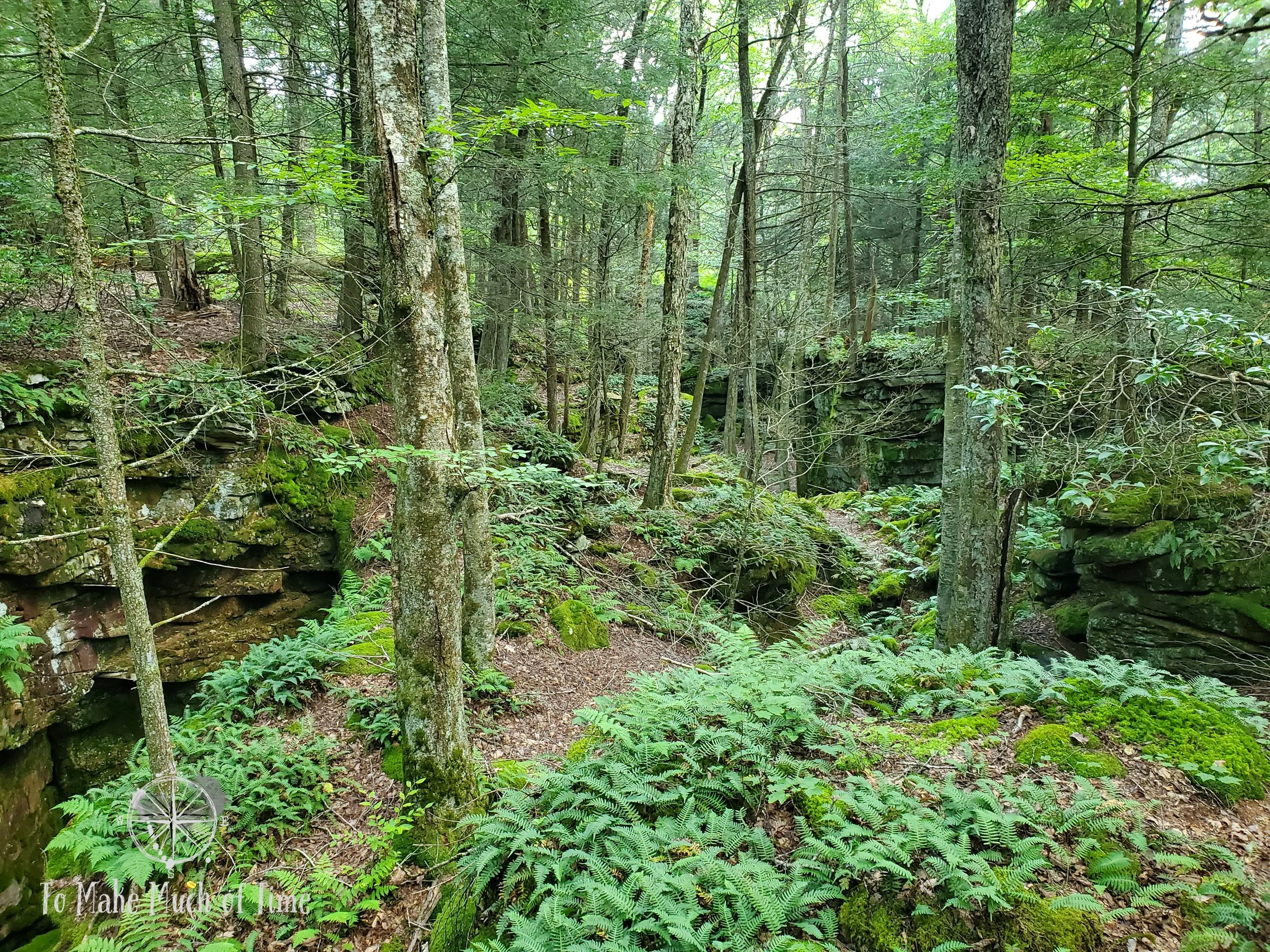
The hidden beauty of Beartown State Park
Related blogs: Want to read more about our travels in West Virginia? Also, this post is part of a 5-part series. Check out the overview of this four-day West Virginia trip here!
Note: Some links throughout our site are affiliate links, which means we may receive a small commission at no cost to you.
On the second day of our trip, we had a bit of a leisurely morning, had breakfast at the cabin, and made a semi-plan for the day. Our first destination was going to be Droop Mountain Battlefield State Park and after that, we considered possibly hitting the Greenbrier River Trail on our bikes.
After swinging by the main park building to access wifi from the parking lot to get driving directions on the phone, we drove the 25 minutes or so to Droop Mountain Battlefield State Park. The route took us through the small area of Hillsboro, past the Pearl S. Buck Birthplace – a gorgeous, white house sitting along a rural thoroughfare. There were some steep altitude climbs and very windy roads, but it was overall an easy drive.
Droop Mountain Battlefield State Park

View from aptly named Overlook Trail at Droop Mountain Battlefield State Park
Droop Mountain Battlefield State Park is a spot where the Union and Confederate troops went head-to-head on November 6, 1863, in the last significant battle to take place in West Virginia. For more details on that battle, you can check out the park site here. While we have certainly visited Civil War battlefields more for the history side, we visited this one to explore their hiking trails first and foremost.
The park is home to eight short hikes – ranging from 0.5 miles to 0.75 miles – with many connecting to each other such that hikers can create longer routes. We first checked out the museum in what was either a small, old-timey house or a successful recreation of one. It was quite similar in style and size to the cabin we rented, in fact. There were a number of artifacts from the Civil War era, including some metalworks like a stirrup from a horse saddle.
Throughout the park were various placards with details about the battle itself in relation to the section of the park you were in. These were relatively few when compared to some of the large, well-known battlefields that I’ve visited but still a helpful glance into the past.
We decided to hike the Overlook Trail, which begins a little bit down the road from the museum, past the cannon. The same point provides entry to Horse Heaven Trail (which we didn’t take) and Big Spring Trail, a spur (which we did). The access point to these trails is at first deceiving. There is a bar across the road expressing no entry, which is really a message aimed at vehicular traffic. Walkers can pass through to access the trails.

Start of the Big Spring Trail

Big Spring Trail

On Big Spring Trail, underneath the Overlook path

Part of the Big Spring Trail

The start to Big Spring Trail starts by descending this path - step carefully!
Big Spring Trail is a spur out and back off of Overlook Trail. While Overlook Trail is 0.5 miles according to the park and Big Spring Trail is 0.75 miles, my GPS clocked in at 0.75 miles in total, but I think that was because several steep elevation changes weren’t really GPS trackable. We spent just under 45 minutes on the trail.
Along these two trails, the Overlook Trail boasts a gorgeous overlook, as should be expected. It also has beautiful rocks, a labeled old bear den, and a small section of marked trenches from the Civil War. It is a pleasant hike through the West Virginia woods.

Path out to the overlook with the valley beyond

Inquiring minds want to know: how do they know the bear hasn’t moved back in?
Big Spring Trail is listed as difficult and begins with a steep descent down rocky stairs before meandering and then heading downhill. And yes, all of this means that on the return, it’s pretty much up hill the whole way. But, given the length of the trail, we found it to be not too demanding, though required caution in footfalls. At the end of the Big Spring Trail is a strongly flowing spring emanating from a PVC pipe placed within rocks. There are wet rocks across the trail. Seeing a trail marker ahead, we thought we were supposed to cross the spring but alas, what we thought was a trail marker said end of trail. We got a kick out of that because it would be far safer to let hikers know the trail ended before they follow the marker across slick rocks.
The trail deposited us back to the parking lot, and we selected our next hike within the park: Musket Trail (0.5 miles) to the Lookout Tower, Old Soldier Trail (a portion of its 0.75 mile total), and finally the Cranberry Bogs Trail (for a portion of its 0.5 miles). In total, this route clocked in at 1.55 miles and just over 45 minutes. While the trails were all very easy, pleasant walks through the area, the real highlight was the Lookout Tower, which has sweeping views of the valley below and mountain tops beyond. We were lucky to be there alone and so could enjoy the views at a leisurely pace. A huge group of adults and children – probably at least 30 people – were eating at the nearby picnic tables and looked like they were maybe part of some group based on the commercial sized river kayak truck accompanying them. Luckily by the time we arrived, they were enjoying lunch so we didn’t have to share the tower.

View from within the Lookout Tower at Droop Mountain Battlefield State Park

View from within the Lookout Tower at Droop Mountain Battlefield State Park

View descending the Lookout Tower at Droop Mountain Battlefield State Park

Old Soldier Trail at Droop Mountain Battlefield State Park
We were at Droop Mountain Battlefield State Park about 2 hours in total, with 90 minutes spent actively hiking, and the rest in the Museum, talking to the park ranger, and the like. With a little under 3 miles in hiking, we were able to hike all or portions of 5 of their 8 trails, so this is clearly not an expansive park, but it is a nice place to spend a few hours taking in nature, views, and history.

View from within the Lookout Tower at Droop Mountain Battlefield State Park

The Lookout Tower at Droop Mountain Battlefield State Park
Beartown State Park
The park ranger was really friendly and helpful and provided us with a few maps of the area. One of the maps he gave us was for Beartown State Park. While I’d seen that noted on lists of things to do in the area, it was only when he explained the park that we realized it was something we really wanted to see. I had assumed it was another park with various trails like the others, but it actually has one trail, which is a half-mile long boardwalk that takes hikers down into and among the huge towering rocks that are representative of the area’s geology.
From high up in Beartown, there are only hints of the massive rock layers that the boardwalk path winds through.

Many of the rock faces had really cool colored growths that were various shades of orange and green.

A close up of the growths and interesting colors on the rocks

Near the beginning of the boardwalk path at Beartown State Park

Rock Cap Ferns atop the rock

Scenery along the Beartown State Park boardwalk path
So, after leaving Droop Mountain Battlefield Park, we headed about 8 minutes down the road to Beartown State Park, the first – but not the last – unexpected adventure of the day.
The rocky towers at Beartown and the feeling they evoke are hard to describe in a way that does them justice. The boardwalk hike is a constant shift between straight sections and stairs up and down, winding hikers down, among, and through the rocky towers. It is a spot so awe-inspiring, that we felt the need to whisper. Though the children who arrived shortly after us felt no such compunction, luckily they never caught up with us!
The area is shaded with towering trees overhead, and light that trickles through provides enough for ferns and mosses. Many of the stone towers are topped with Rock Cap Ferns that makes it looks like they have a head of hair. The rocks have lots of interesting layers, striations, and warm hues. This was one of those places that we would never have planned to visit, and we’re so glad that a passing conversation with a park ranger led us there!
We returned to our cabin for a late lunch and to walk the pups. We had planned on biking some of the Greenbrier River Trail but decided after all of the morning hiking, we’d give our legs a break and drive the Highland Scenic Highway. This thought is hilarious in retrospect given that we ended up hiking a few more trails before the end of the day.

This picture provides a sense of scale - taking from a lower part of the path with an upper portion visible up high.
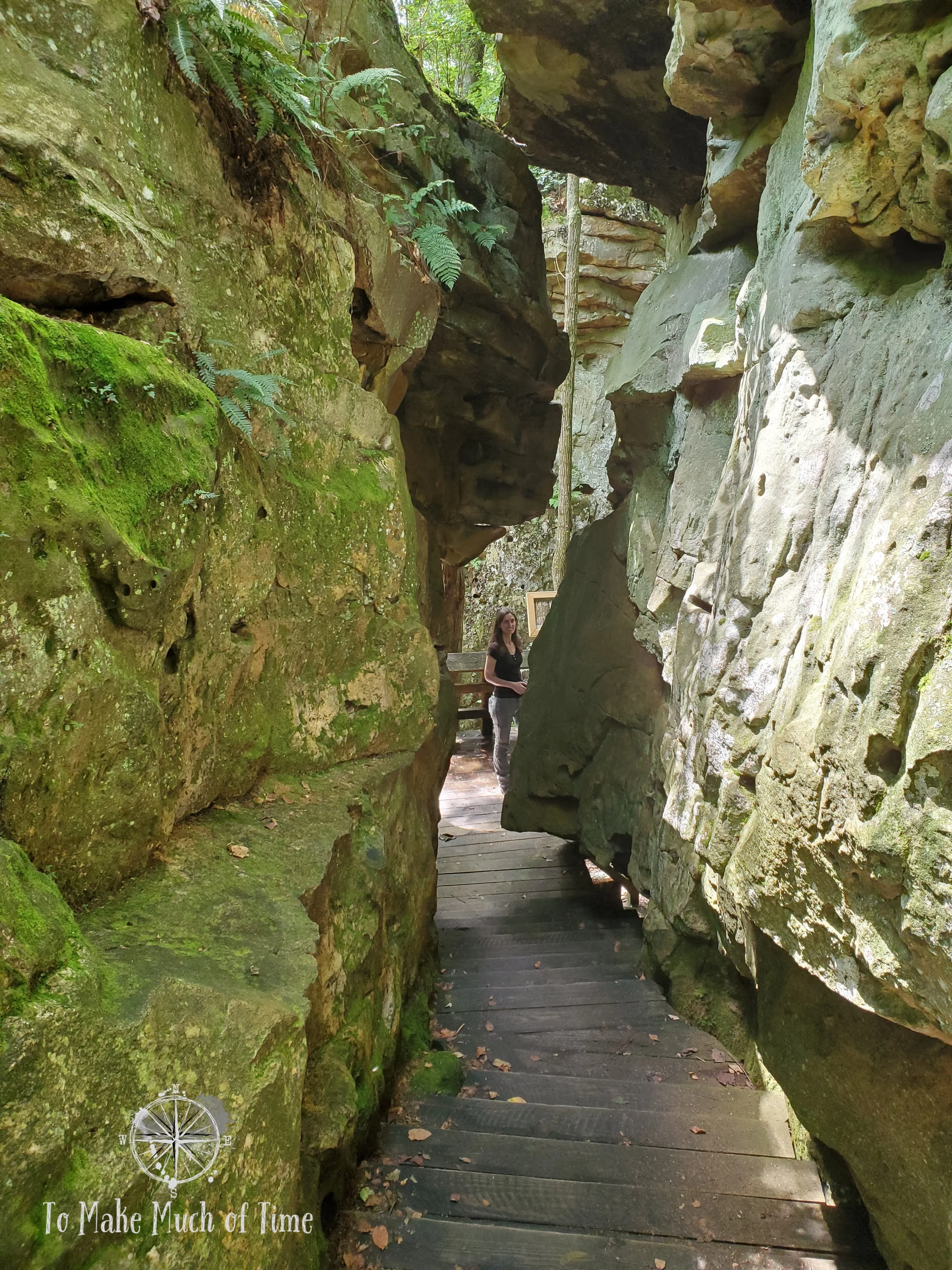
The engineering and labor that must have gone in to building this!

Some nature makes you feel even smaller
Highland Scenic Highway
The Highland Scenic Highway is part of the roads designated as a National Scenic Byway. It extends 45 miles through the Allegheny Highlands and Plateau and has more than a 2,000 foot elevation change, providing sweeping views of the surrounding mountain chains and valleys. There were signs that the road is often closed or unsafe during the winter months, and in West Virginia at that elevation, that means plan your trip in the May to October time period.

View from a scenic overlook on the Highland Scenic Highway

View from the Highland Scenic Highway

Wildflowers and view from the Highland Scenic Highway
We set out on an hour and a half loop drive with plans to only drive and take in the scenery. One of the first scenic overlooks we came to had the short Cranberry Glades Overlook Trail (0.5 miles), which sent us out to a beautiful overlook of the surrounding area, and we were introduced to Rowdy the Raven on the sign. Apparently he (she?) lives in the area and pops up on a multitude of the scenic highway signs to explain how far distances are. At this stop, we heard a raven in the distance and at Little Laurel scenic overlook, we actually saw a raven on the ground before it saw us and took to the air. Was it Rowdy? Is Rowdy even Rowdy or a generic name that can apply to all area ravens? So many questions.

Hiking the Cranberry Glades Overlook Trail

A small bridge on the Cranberry Glades Overlook Trail
After a ways, we came to Little Laurel scenic overlook and pulled off to take in the views – again, gorgeous blue rows upon rows of mountains extending as far as we could see. The information panel encouraged us to take a “short walk” through a meadow path just behind us. Across the Highland Scenic Highway, we could see the entry way to a meadow jaunt and decided to check it out. And ended up hiking over a mile round-trip on the Tea Creek Meadow Interpretative Trail. As a sign shared, what is now the meadow, filled with wildflowers and undulating grasses was a spot where they dumped residue – gravel, dirt, etc. – from the building of the roadway. When the road was built, they added grass and let nature take her course.
We spotted Monarch butterflies and many other varieties that are unfortunately unknown to us by name. There were a large variety of flowers including Black-Eyed Susans, Cone Flowers, etc. The trail was an out-and-back trail that wrapped around the meadow before veering downhill into a forested area and finally ending up at a boardwalk area with two separate viewing areas with blinds over a marshy pond. From there, there was a lot of up-hill!

The entrance to the Tea Creek Meadow Interpretive Trail

The wild grasses on the Tea Creek Meadow Interpretive Trail were really tall, which I tried to capture in this image.

There were broad, sweeping views from the Tea Creek Meadow and not another person or road to be seen (even though the near was nearby).

I love the sweeping pattern of these grasses along the Tea Creek Meadow trail!

Wildflowers - such as thistles - dotted the trail

And Black Eyed Susans

There were a multitude of butterflies, such as this spotted brown one. They move quickly so are tricky to capture!

This bright red dragonfly was very hard to photograph, so I was thrilled to get a decent shot!

Tea Creek Meadow Interpretive Trail off of the Highland Scenic Highway. This meadow was created from the rubbish pile left behind after the road was built.

When the trail headed downhill towards a forested area, there were some marshy spots off to the side with even more pervasive grasses.

Within the forested area were a couple of short boardwalks (the ground was marshy) that led to vistas that are prime spots for birds, though they were sparse on a summer afternoon.

The view at the end of the trail, before we headed back up hill and retraced our steps.
At that point in the day, it was much later than we had meant to be out. Our Highland Scenic Highway drive had turned into a drive and hike inadvertently (oops!) so we ignored any pull of future scenic overlooks and headed back to the cabin through the town of Marlinton, which seemed like a cute mountain town with a smattering of shopping options (the first grocery story and pharmacy we’ve seen on this trip), some local restaurants, and gas stations. The downtown itself had some character and is home to the county’s opera house. Always a lover of cute, small towns, this one appealed to me. Between the Greenbrier River and corresponding rails-to-trail route and all the area hiking and beautiful mountain scenery, the town has everything in the way of setting.
At the cabin, our dogs let it be known to us that we were serving them a late dinner by eating it with intensity, gusto, and speed. Oh wait, that is how they always eat it. And is dinner really late at 6pm? We have a huge guilt complex when it comes to our dogs, and I’m pretty sure they use this to manipulate us. We ate the homemade pizza that we had brought with us from home. Dustin has spent years perfecting his crust and playing around with toppings, and the multiple meals the pizza provides made it a great option to make and pack.
While we were pretty tired, we decided to check out the night sky given that Watoga State Park is a Dark Sky Park. We went to a spot recommended to us - the Ann Bailey Trailhead. We had checked out the spot the evening before while it was still light and had enjoyed the sunset over a sweeping vista. We arrived around the time that our phones told us would be the ‘last light’ of the day, about 30 minutes after the sun officially set. Yeah, we knew it would take a while for it to get truly dark, but it took much longer than we expected! We ended up sitting up at the expansive overlook, watching the night sky for much longer than we realized – 90 minutes had flown by when we turned the car back on to leave. We were able to get some night sky photography with our tripod, which luckily we had packed. Well, when I say we, I mean Dustin. With a dark forest nearby, I was not keen to stand outside in the dark, so we also spent a chunk of the time with our SUV’s skylight open, standing with our heads out, watching the Milky Way overhead, and losing count of the number of shooting stars that shot out at random, part of the Persiad meteor shower.

The tail end of sunset at Watoga State Park
Click the image below to save this post to Pinterest!
